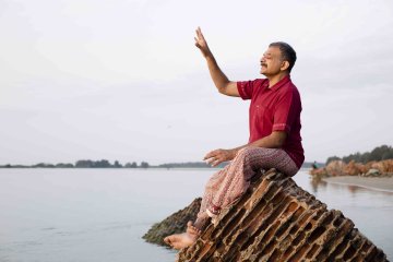
The deluge has washed
over Chennai and the waters have receded, leaving behind a weary waste of
household wreckage wherever the eye lights. Still, the city is beginning to
sort itself out as the sun is shining again. For some people, however, the
worst is now as they contemplate ruined homes and the destruction of all the
value they had so painfully built over the years. The state government is
beginning to move into gear but it is bound to be slow work. Rehabilitation is
mainly its responsibility and this time there is a great deal at stake with an
assembly election just months away.
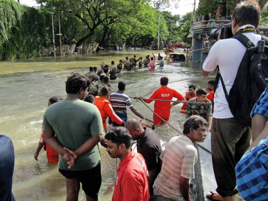
As the initial numbness wears off, more and more people are asking what happened and why. Why were they never given an idea of how unprepared the city was for the monsoon? Why, 10 days after the event, were entire localities still inundated? The top echelon of the administration, which is supposed to lead from the front, appeared clueless both before and after the deluge.
The rain is, of course, a large part of the explanation. This was an unprecedented monsoon with the precipitation breaking all-time records, three separate events of all-day rain that overran by many times the capacity of the city’s drainage system. Meanwhile, the Adyar River, swollen far beyond its usual limit by rain in its catchment area and, possibly, massive inflows from the various lakes and tanks along its course swept through the city, breaking its banks and for a brief while taking back its old flood plain, with disastrous results for the people occupying it.
This line of narrative
is perfectly true but does not explain how and why people came to be living on
the flood plain. Surely the city’s engineers are aware of the risks attending
such a scenario. Take the case of the Kotturpuram housing for economically
weaker sections. Anyone crossing the Adyar at Kotturpuram is bound to see the
rows of flats huddled across one of the banks of the river. The peeling institutional
once yellow walls and the boxy shape are like a government stamp. These flats
were built by the Tamil Nadu Slum Clearance Board for poor people. They’re
almost in the riverbed.
Presumably there was a study before the project came up, but there they are, flirting with, inviting disaster. The occupants have suffered not one but several encounters with flood water. In 1985 it reached the second floor. This time, too, when the Adyar broke its banks the EWS flats were under water up to the first floor. It remained that way for days on end, with many residents marooned because Kotturpuram was one of the most difficult areas to reach.
What makes this case particularly noteworthy is that the builder is not a fly-by-night operator but the state. The occupants are not illegal squatters but have titles awarded by the state. Yet they are living in an area where the threat of flooding is ever-present. They are so close to the Adyar that even a small increase in river flows becomes problematic.
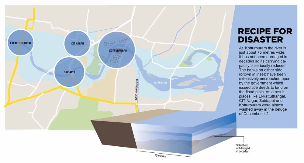
The rest of Kotturpuram is similarly situated. The high value residences are less vulnerable but this time the entire area, with a few exceptions, was under four to five feet of water, from the Adyar and the nearly 40 centimetres that poured down on December 1-2. Again, this layout is officially sanctioned. Whether all of it is in the river’s flood plain is not entirely clear but there is no provision for draining the excess. If the river breaches its banks, Kotturpuram residents have two options; flee their homes or stay and suffer the consequences.
Indeed, there is more than one report by expert committees highlighting this danger. Here is an excerpt from a 2008 study.
“Problems due to flooding may be attributed to:
(i) The change in land use leading to increase in runoff volume with reduction in time of concentration;
(ii) Encroachment along the banks of the river;
(iii) Inadequate storm water drains and their poor maintenance; and
(iv) In urban watershed, inundation occurs even for a low intensity short duration storm.”
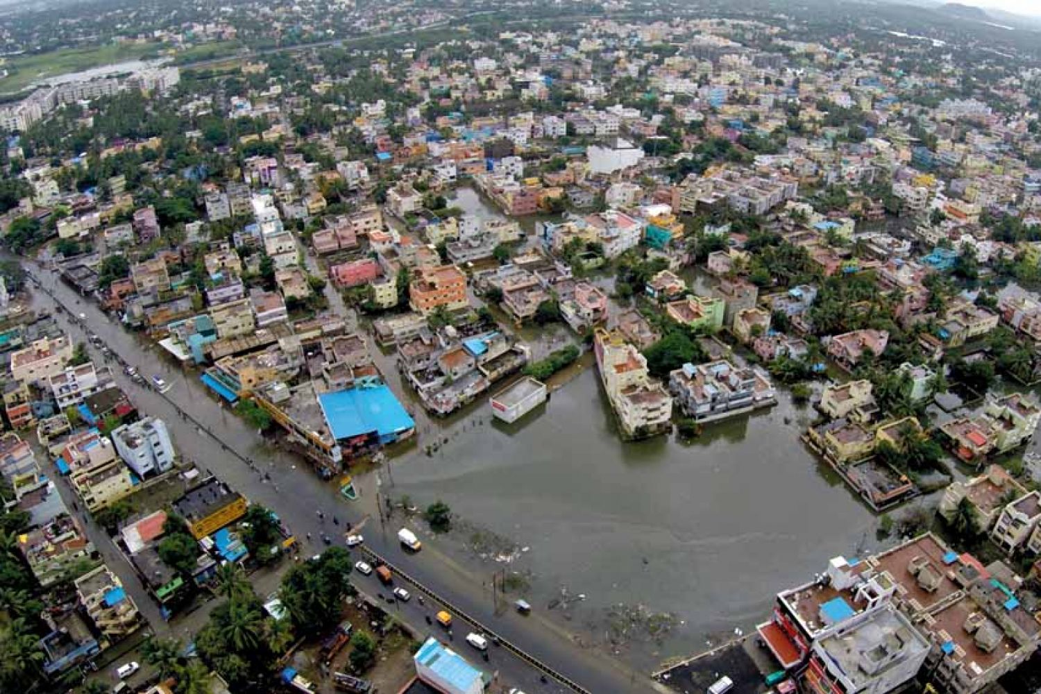
The first point is the key one. It means that the flood plain has been encroached upon for several decades as the city grew. Large parts of the plain were converted into patta lands (ownership approved by the state government). It had two consequences. The first was that construction on these patta lands reduced their capacity to retain water. The runoff has increased steadily over the years. Secondly, the river had no place to go as its “right of way” was progressively taken away. In some places up to 30 per cent of the plain was lost to officially approved encroachment. The result of this approach is that projects and layouts in these areas are always vulnerable in times of heavy rain. In the deluge of December 1-2 when the river was discharging up to ten times its usual load areas such as Kotturpuram, Ekkattuthangal and Saidapet were the first to be affected. The situation was compounded by the lack of alternative drainage, and the three factors created a positive feedback loop to wreak havoc.
In other words, successive state governments since the 1970s are primarily responsible for the mess. They ignored the warnings of their own experts and sanctioned development plans without thinking of the consequences. When these same experts pleaded for mitigation in the form of a drainage network it was delayed for various reasons. Permissions for building, however, continued to be given regardless of the capacity to handle sewage and storm water discharge. After a point any city planner would have known that the structure was unsustainable. December 1-2 was the knockout punch that followed the body blows dealt by the wettest November in decades. The real culprit, however, is the government’s mindless destruction of built-in safety valves such as flood plains and the city’s lakes and tanks, which held the runoff and recharged aquifers and wells in the vicinity.
Hindsight is a great
thing and can prevent every tragedy before it begins. Unfortunately, it is
always after the event. Nevertheless, it is a temptation to see what might have
been saved if existing safeguards had been exploited. The Adyar, for instance,
is just about 42 kilometres from source to mouth. About half of that flows through
Chennai city. It rises from three sources, the Chembarambakkam lake basin,
Guduvancheri in Chengalpattu district and Malaipattu tank in Manimangalam
village of the same district. The three streams join at Thiruneermalai to form
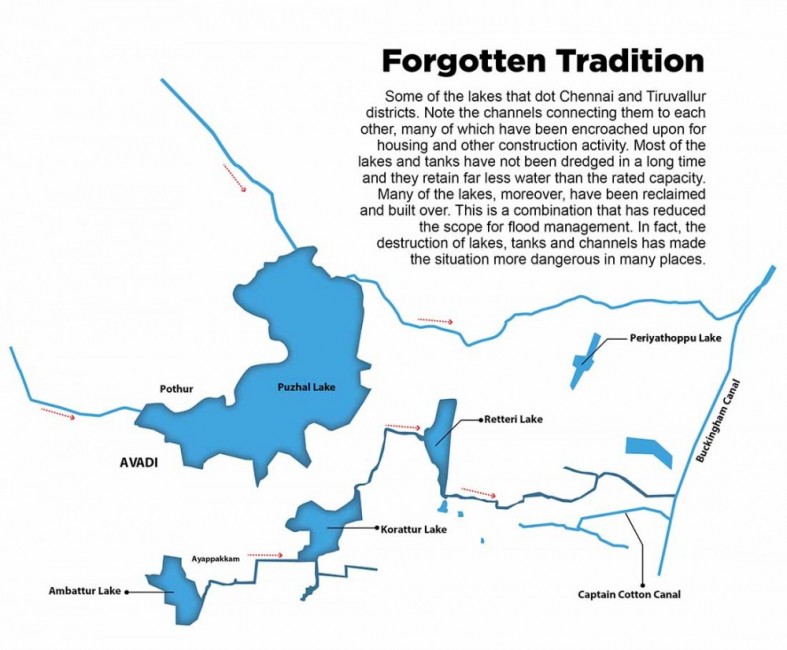
the Adyar. Its watershed has 109 lakes and tanks, large and small, natural and
man-made that act as feeders.

These water bodies are part of the magnificent water management network handed down to us as a more than 1,000-year-old legacy. Southern India, especially the old Tamil country, has few substantial rivers. Water was a problem even in the best of times as there are no perennial rivers of the kind that flow across the north. The only solution was to store rain water and reduce the runoff to the sea. That is the origin of water harvesting. It continues to prove its worth even today as about one-third of the area under paddy in Karnataka, Andhra Pradesh, Telangana and Tamil Nadu is irrigated by tanks, or ery as they are called. The Kaveripakkam tank, one of the largest and oldest in Tamil Nadu, is said to have been built by Nandhivarma III (846-869). It covers an area of 16.06 sq km.
The ery is a small body of water formed by damming a natural depression with bunds or embankments on three sides and leaving the fourth side open to the water that flows in from the catchment area. Water is stored for irrigation, drinking and recharging aquifers. Overflows are released through a weir and water for irrigation by a sluice which directs it into channels built to cover the entire designated area or ayacut. It is a small but precise feat of engineering designed for purely local conditions. There are thousands of these tanks or ery across Tamil Nadu.
In the 1850s a British engineer, R. Baird Smith observed in a report on irrigation in Madras Presidency:
“The extent to which it (irrigation works) has been carried throughout all the irrigated region of the Madras Presidency is truly extraordinary. An imperfect record of the number of tanks in 14 districts (of the Madras Presidency) shows them to amount to no less than 43,000 in repair and 10,000 out of repair or 53,000 in all. It would be a moderate estimate of the length of embankment for each to fix it at half a mile; and the number of masonry works, in sluices of irrigation waste weirs, etc, would probably be not over-rated at an average of six.
“These data, only assumed to give some definite idea of the extent of the system, would give close upon 30,000 miles of embankment (sufficient to put a girdle around the globe not less than six feet thick) and 3,00,000 separate masonry works. The whole of this gigantic machinery of irrigation is of purely native origin, as it is a fact that not one new tank has even been made by us, and the concurrent testimony of those best informed on the subject shows that a great many fine works of the kind have been allowed to fall into utter disrepair and uselessness.”
A Tamil Nadu government report of 2005-06 states that there were 40,319 tanks irrigating 5,75,352 hectares in various districts. More than half the irrigated area in Kancheepuram district was under tanks.
A Tamil Nadu
government report of 2005-06 states that there were 40,319 tanks irrigating
5,75,352 hectares in various districts. More than half the irrigated area in
Kancheepuram district was under tanks. A system that at Independence was deemed
primitive and having outlived its usefulness continues to be central to the
lives of lakhs of people even today. This is a regime, moreover, that lends
itself naturally to flood control as the ery are generally
linked to each other in clusters by channels.
The overflow from an ery at a higher contour line was directed to one at a lower line by channels dug for the purpose. The system at its best was like a giant man-made sponge soaking up large quantities of water in times of excess, retaining it to recharge water tables and reduce the pressure on small rivers like the Adyar that are prone to flash floods in the monsoon. The system would also check soil erosion, a big problem for small rivers which silt up quickly, reducing their ability to hold water during a flood.
So far, not a single report on the deluge of November-December has even mentioned the condition of the 109 lakes and tanks in the Adyar’s catchment, much less whether the links and channels between them were in sound condition or the extent to which they were overwhelmed by the sheer volume of precipitation. The worst affected districts of Chennai, Tiruvallur, Chengalpattu and Kancheepuram have over 3,000 tanks and lakes. Were they made ready for the monsoon and did they play a role in the flooding? Information on this would at the very least clarify whether the PWD did its job.
For a city that is so
desperately short of water Chennai is prone to flooding, especially in
so-called low-lying areas. Usually it is worst in the suburbs, though central
areas such as T. Nagar and Mambalam are also susceptible. Parts of north
Chennai outside the original town are also vulnerable. This time even the
ultra-posh Boat Club area was inundated but there are many parts of the city
that go under even in the southwest monsoon. The one reason everyone mentions
is that there are over 5,000 kilometres of road length but only a third of that
has a sewer system to drain water. The rest are condemned to stagnant water
when it rains heavily, for hours if they are lucky, days if not. There is
little mention of the other factor, which is probably far more decisive.
Most of us living in the city feel we’re really unlucky if our localities get flooded after an hour-long downpour. But luck has nothing to do with it. This is institutional stupidity at work. Take an old map of the city and lay it on the latest one. Many of today’s localities don’t exist but if your area is particularly prone to inundation, there’s a good chance that it was either on the edge of a lake or was part of a lakebed.
The old city of Madras
was full of erys across its length and breadth. The precise
number is a matter of debate but there seems to be general agreement that it
was over 120. A great many of them have been filled up and built upon, for
instance, the so-called Lake Area that spans Nungambakkam and parts of T.
Nagar. This is one of the perennially problematic localities. Even a short
sharp shower sometimes causes flooding and major traffic problems. Parts of
this area had four to five feet of water on the streets, and were unreachable
for days after the deluge. Residents were marooned without power or water. The
only food was what they had before the rain started. Dry ground was just
minutes away in some cases but there was no way of getting to it.
So there is lots of real estate, lots of wealth but hardly any thought to water management, which should have been central to the world of the urban planner. No one seemed to realise what might happen if a city was built over its lakes rather than around them.
In fact, the entire area from Nungambakkam through T. Nagar, Mambalam and up to Saidapet (among the worst affected areas) was part of a massive continuous system called Nungambakkam Lake-Long Tank until the 1920s. Is it any surprise that they should be vulnerable to flooding, especially as the drainage system is still so basic? The system drained the areas around it but once it was filled up there was no place for the overflow. The alternative drainage is simply not good enough to cope, given that the runoff is so much more in this highly urbanised, totally built up space. In the old days open spaces would have absorbed some of the water. Now there is hardly any left.
So there is lots of real estate, lots of wealth but hardly any thought to water management, which should have been central to the world of the urban planner. No one seemed to realise what might happen if a city was built over its lakes rather than around them. Look at the contrast with the men who built the ery system. In his paper on “The Ery Systems of South India”, T. M. Mukundan notes: “Only recently, modern irrigation experts have begun to consider an entire irrigation basin as an appropriate unit for designing irrigation systems. This was an established practice in ancient times.” This was the vision that created the intricate network of ery and their connecting canals. The outcome was a system that maximised control and minimised mishap.
For instance Malaipattu tank, one of the Adyar’s sources, had extremely heavy rain and was running full two weeks ago when my colleague Saurav visited it. But in the nearby village of Manimangalam residents barely wet their toes. The same was true of Chembarambakkam as well. Even after this deluge the residents around seemed safe if shaken by its intensity. A district-wide survey would be interesting; perhaps even provide a clue about where to site dwelling places.
There is perhaps some
excuse for inner Chennai where development took many decades and there was
enough provision on paper for a complete drainage system. But it was never laid
in full. Though it was informed by a general ignorance of hydrology, many
senior PWD engineers of the time did sound warnings more than once. The same
reasoning cannot be used for the IT corridor running parallel with the East
Coast Road on Old Mahabalipuram Road.
Most of the area was a freshwater swamp until independence. Pallikaranai was once a complete aquatic ecosystem spread across approximately 80 sq km, the city’s only surviving wetland and one of the last remaining natural wetlands of south India. It is also a vast drain for the excess of monsoon precipitation in a catchment area of about 235 sq km. The volume of water it can hold is thus impressive.
Beginning in 1806 for the Buckingham Canal, it has been encroached upon by successive generations for various purposes. Today about 90 per cent of the marsh has been lost to development but the shrinkage was gradual until the IT corridor was designated. After that it was a virtual gold rush and free-for-all as the area was swamped by real estate developers, all frantically clearing, filling and building in a desperate rush to grab the jackpot. Pallikaranai was a place under siege.
It became a part of the Chennai Corporation in 2011 and is one of the country’s top investment destinations in residential real estate. A report by global property consultancy Knight Frank estimated that housing prices would increase 93 per cent in the period 2012-17. It’s a home for tens of thousands of rising young things housed in a myriad high-rises and working from other high rises in the area and outside. The villages surrounding the marsh turned almost overnight into prime real estate. In the process virtually every warning about drainage, low-lying areas, danger of inundation was ignored. Build or perish was the slogan and perish they nearly did in the last couple of months. Dream locations became waking nightmares of steadily rising water as the rain bucketed down.
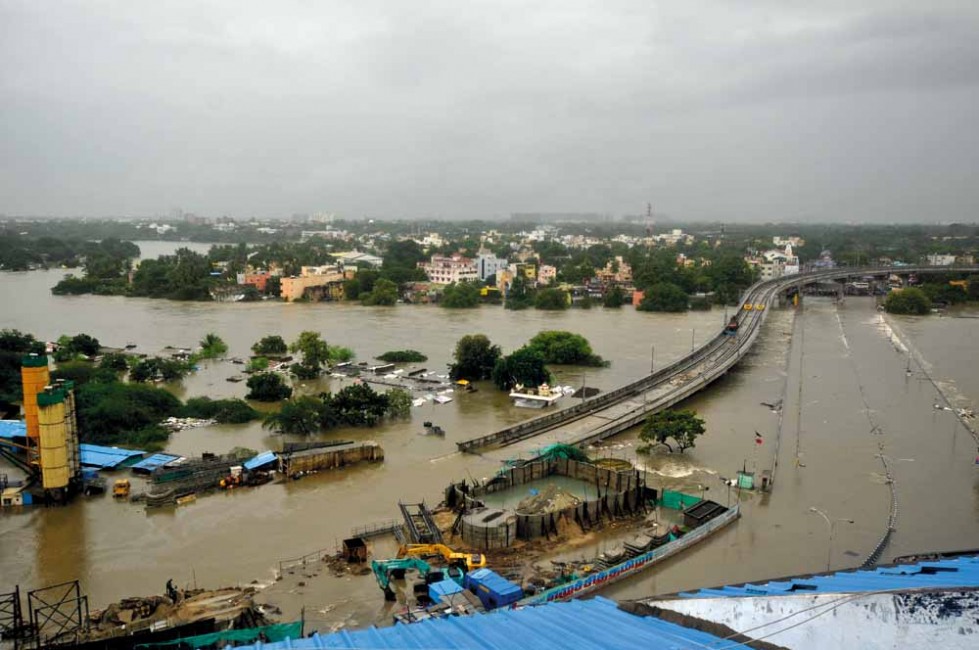
OMR, as it is known,
was one of the worst affected districts of Chennai in the deluge. Roads were
washed away or became like canals, thousands of people were stuck in their tall
buildings without power or water or food, and when the water receded the place
was initially unrecognisable. The OMR disaster is the result of administrative
neglect and dereliction of duty by virtually everyone in power, from ministers
downwards. The principal culprit is indiscriminate planning permission without
providing for drainage and the second is the inability by both builders and the
authorities to recognise that this is where the water pools when there is too
much of it. There is no other place for it to go. Given the conditions, what
happened was inevitable. What was on display was not the power of nature but
the power of institutional stupidity. Few things are deadlier.
The last question to
ask is, will the government learn from the disaster, start remedial work and be
more strict about enforcing the rules? The answer is still blowing in the wind,
but past experience offers little encouragement. There’s more money in breaking
rules than in enforcing them.

is consulting editor, Fountain Ink.